With Geocachers looking for ever more ways to make their caches challenging and individual, having a lock to open without a key is gaining popularity. This isn’t without controversy, even owning a set of Lock picking tools in some countries is illegal, however, in most countries this isn’t the case. ‘Lock-picking’ has an image problem in the general public’s mind, which is largely unfounded. Before we start, a large caveat, if it can be shown that the tools in your possession are intended for illegal purposes, then expect the full weight of the law. Being able to demonstrate permission to open a lock is everything here. All caches of this type should have the fact that “there is a lock to defeat (Pick, bump etc)” stated very clearly in the Geocache description, or else the act of opening it would stray into the grey area as to the legality of opening the lock (see lock sport rules at the end of this piece). There’s far more legal complexity that I can cover in this short article and.. I’m not a lawyer.
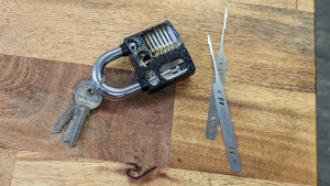
Given that defeating locks is a life skill that few of us possess, there is a hobby called Locksport where you can learn. Locksport is based around defeating locking system using a variety of skills traditionally known to a small group of people in the associated professions. Locksport has its roots in the broader field of lock defeating or picking, a skill that has been practiced since the very first lock was made. However, the organised and recreational aspect of lock picking, known as locksport, did not appear until the latter part of the 20th century.
The origins of locksport can be traced back to the hacker and computer security communities who regarded any closed system as a challenge. As computer enthusiasts explored the digital realm, many found a parallel interest in physical security, including the mechanisms that safeguarded valuable information. Lock picking became a hands-on extension of the broader ethos of exploring and understanding systems.
In the 1990s, groups like the MIT Lockpicking Club and the Open Organisation of Lockpickers (TOOOL) started formalising and popularising the recreational side of lock picking. TOOOL, an organisation from the Netherlands founded by Barry Wels and Deviant Ollam in 2002, played a significant role in promoting locksport globally. The organisation aimed to advance the public’s understanding of locks and security through educational initiatives, training, and organised events, constantly working with the public and manufacturers to highlight lock vulnerabilities.
Locksport events, often referred to as “lockpicking villages,” became a staple at hacker conferences and conventions. These gatherings provided a platform for enthusiasts to share knowledge, exchange techniques, and engage in friendly competitions. The focus was on education, ethical behaviour, and responsible use of lock-picking skills.
Locksport has evolved into a diverse and inclusive community that welcomes individuals with varied backgrounds, from hackers and security professionals to hobbyists and locksmiths. The emphasis remains on education, skill development, and fostering a sense of responsibility in using lock-picking knowledge.
In the past two decades, the popularity of locksport has grown, with local groups forming both offline and online, bringing together like-minded individuals who share a passion for this unique skill. The community continues to promote a positive and ethical approach to lock picking, emphasising the importance of understanding security systems to enhance overall safety and awareness.
To keep lock-picking skill away from those who would abuse it, members of locksport groups have zero tolerance for illegal or immoral lock picking, bypass, or other forms of entry.
Locksporters abide by the following rules, with no exceptions:
- Locksporters may open only locks that belong to them. For other locks, they need express consent of the owner.
- Locksporters may not open a lock that is in use.
- Permanently removing (or relocating) the lock may be done only when lawfully and specifically sanctioned by an appropriate authority.
- A lock which has been effectively abandoned by its owner and placed in a public place without securing anything (i.e., not “in use”, such as a lock placed on a “lovewall”) may ethically be picked by any locksporter, provided the lock is returned to its original locked position and state.
- The security needs of others must be preserved.
- All activities take place within boundaries of respectability, integrity and professionalism.
- Further reading
- Locksport Wikipedia Entry
- Lockpicking guide
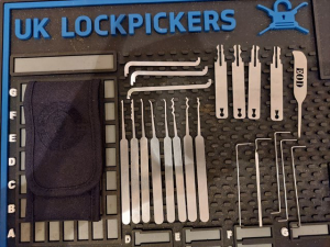
- Uk Lock Pickers A one stop shop for all Locksport needs
- THE OPEN ORGANISATION OF LOCKPICKERS WORLDWIDE
- Lockwiki


