Our GPS history and why we still use them along with our phones

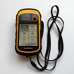
We have been using a GPS since we started Geocaching way back in 2010. Our first GPS was the eTrex 10 with no maps, we just ‘followed the arrow’, it did however support downloading Geocaching GPX files via USB which made it ideal for Geocaching. A testament to the eTrex’s toughness and simple design is that this model, although revised is still available today. It was bomb proof had no touch screen just a thumb-operated joystick, monochrome display and a pointer to where the destination was, and how far away it was. The eTrex has exceptional battery life but was slow to get a signal and its accuracy was truly hit or miss under tree canopies. This little unit spawned many adventures for us.

Garmin eTrex 10 Patche99z, CC BY-SA 3.0, via Wikimedia Commons

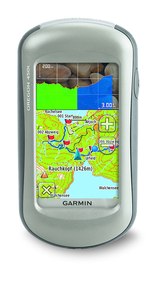
After a few years of finding ourselves on the wrong side of a river or having to make a long hike due to a dual carriageway or some other obstacle blocking our progress we decided on the Oregon 450T which had Ordnance Survey maps 1:50 k. This was a revelation and for the first time allowed us to see a map which allowed us to plot a route unhindered by obstructions. The Oregon 450t had a touch screen, a SD card slot for maps and extra data, an electronic compass, a barometric altimeter and could store thousands of Geocaches. We got about 6 years of use and abuse out of these units. Maintenance, mainly due to rough handling, resulted in screens being replaced, buttons fixed and other sundry parts replaced until they both were beyond repair. I recycled parts from both and with some bits off a Russian GPS breaker on eBay, a ‘Frankenstein’ Oregon 550 GPS was created, this had all the same features as the 450T it now sported a 3.2 megapixel geotagging camera. Although this unit has now slightly out of date OS maps it is still fully functional and in constant use to this day.

By Garmin - garmin.com, CC BY-SA 3.0,
Garmin 450T By Garmin – garmin.com, CC BY-SA 3.0,

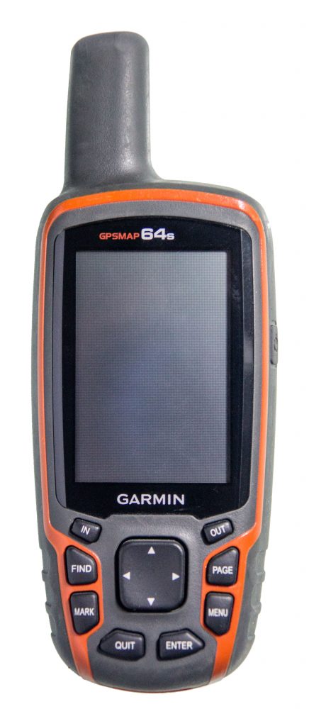
I personally own a Garmin GPSMAP 64s now, I never liked the touchscreen which with my big hands didn’t work so well for me, I love the buttons and simple menu system. The unit has a good sized display that can be read in bright sunlight which was always a problem with the older models and mobile phones. The reception is great even under trees, and the unit is quick to get a GPS lock. The 64s uses GPS + GLONASS + WAAS although not Galileo. I also 3D printed a simple mod that allows rechargeable batteries to be used and charged in the unit whilst connected to USB. Bluetooth is available and in reality only useful for transferring Geocaches to another compatible unit, it’s a battery killing extra I don’t need and is designed for external sensors like heart rate, therefore remains switched off.

Garmin GSMAP 64S By Virgilinojuca – Own work, CC BY-SA 4.0

So why do we still use this old tech? We get at least a couple of days battery life out of both the 550 and 64s which is a lot more than our mobile phones. If the battery runs out we just pop in another couple of AA batteries and off we go. They survive rough treatment much better than mobile phones. Detailed maps can be downloaded from sites like Open Street Maps and preloaded on SD Cards, these are always available even when there is no phone signal, this is also great for caching abroad where maps can be preloaded. They accurately track our route which can be examined in Garmin’s Basecamp software when we get home. I’m not saying GPS units are more useful than mobiles, but a phone with apps like Geocaching, C:geo, Looking 4 Cache is a perfect compliment to a GPS.

GPS Systems

GPS is now a part of everyday life, the ability to know exactly where you are on the planet was the dream of every navigator for millennia, now this is available at the press of a button. GPS is widely used in a variety of technologies such as mobile phones apps, cars navigation for both mapping and incident reporting, wildlife tracking which has yielded some interesting results for migratory birds and mammals and preventing crime by tracking desirable objects. This tech has only been available to the public since the year 2000 and has since become the most popular method of accurately establishing a location within metres. 

Introduction

A short history of GPS Systems

The first publicly available Global Navigation Satellite Systems (GNSS) was the USA’s Navstar GPS satellite constellation. This was a satellite-based radio navigation system owned by the United States government established in 1978 for the USA military and made public in the year 2000 by the Clinton administration. America’s newest GPS system is now just one of many that provide geolocation and time information to a GPS receiver anywhere on Earth where there is an unobstructed line of sight to four or more GPS satellites. Other GPS systems include Russia’s GLONASS, the European Union’s Galileo, and China’s Beidou Navigation Satellite System which offer varying degrees of accuracy, the Galileo system being the most accurate at less than 1 metre for public use and up to 20 cm accuracy for paying customers in 2021.

NAVSTAR Global Positioning System satellite
Artist’s concept of a NAVSTAR Global Positioning System satellite, a space-based radio navigation network.

How does a GPS work?

GPS systems use sets of dedicated satellites, called constellations, these are not stationary but are circling the earth so ‘rise and set’ twice a day, the satellites constantly send out signals, the GPS receiver listens for these signals they don’t transmit anything back to satellites. To determine the location of the GPS satellites two types of data are required by the GPS receiver: the almanac and the ephemeris. The almanac contains information about the status of the satellites and approximate orbital information allowing the receiver to see which satellites should be visible. After establishing what satellites should be available for you to get a fix, your GPS receiver requires additional data transmitted by each satellite, called the ephemeris, this data gives very precise information about the orbit and location of each individual satellite. The GPS receiver uses the ephemeris data to calculate the location of a satellite within a couple of metres and then by using the information that was transmitted to the GPS, your position can be calculated by triangulation using the delta in time signal transmitted and when it was received plus the location of the satellites. The ephemeris is updated every 2 hours and is usually valid for 4 hours, so If your GPS receiver has been off for a while, it may take up to several minutes to receive the ephemeris data from each satellite, before it can get a fix, this is known as a cold start. Obstacles such as mountains and buildings block the relatively weak GPS signals, this will ‘lengthen’ and therefore distort the time to receive the data or even give a false location. On a Mobile phone, there is an additional A-GPS mode which uses the cell towers to calculate the initial position of the user very quickly but with less accuracy, unlike pure GPS this may send information back to a server where that might be helpful to process position. Once the receiver calculates its distance from four or more GPS satellites, it can figure out where you are to approximately a 7.8-metre accuracy and depending on the system in use the accuracy might increase. Using GPS for locating a point of the earth is a key component for Geocachers in their quest to find caches, hence the saying follow the arrow.

Photo: ©GSA, ©European GNSS Agency
One of the Galileo Satellite Constellation

Tips and tricks
1 Having obstructions between the GPS and satellites causes issues where 3 – 4 satellites cannot be seen simultaneously, this is most often seen in cities and forests where accuracy quickly degrades.

2 Multi-path or Signal reflection occurs when the GPS signal is reflected off buildings or other objects, this can delay the time-clock signal sent out by satellite and cause a miscalculation again resulting in degradation of accuracy.

3 In the Northern Hemisphere Face the internal Antenna toward open Southern, SW, SE, in the Southern Hemisphere revers this, most of the satellites are clustered around the equator, this will make getting a fix and maintaining on easier.

4 Low batteries invariably cause issues with GPS systems, make sure that your batteries aren’t on their last legs.

5 When you switch on GPS after moving more than 25 miles or replacing batteries keep it in one position in the open air to allow the ephemeris data to update, it will get a fix far quicker than moving with it.

6 Keep firmware up to date, if there are any bugs in your GPS program an update will fix the issues. If there are more up-to-date base maps in GPS standalone system, an update will repair that, too. 

7 GPS systems are not infallible so use common sense and your Mk 1 eyeball to check what you are being told by the system matches reality, learn to read a map and research where you are going. Most Geocachers will have stories of reaching a river or cliff face and being just meters from a cache that could not be reached without retracing their steps and trying another path. 


Blue Switch Day

Global Positioning System (GPS) when first developed was only available to the US military. Later civilians were allowed access with Selective Availability (SA) but the GPS signal accuracy was greatly reduced.

May 2nd 2000, on the instructions of President Bill Clinton, the US government turned off its Selective Availability. By “flipping the switch” everyone had access to high accuracy GPS signal. Twenty-four satellites around the globe processed their new orders, and instantly the accuracy of GPS technology improved tenfold. Tens of thousands of GPS receivers around the world had an instant upgrade. Even though there was not a blue switch, for some unknown reason, geocachers refer to this day as Blue Switch Day.

With the availability of accurate GPS signal the world changed forever with the introduction of new technologies that today we take for granted. Gone are the days of the road atlas!

May 3rd 2000 saw the first geocache hidden by Dave Ulmer in Oregon and the beginning of the game that we know today.

2017 Souvenir

In celebration of this Blue Switch Day geocaching first introduced a souvenir in 2017. To obtain your Blue Switch Day 2021 souvenir simply find either a geocache, an Adventure Lab or attend an event anytime between May 2nd to December 31st.

Doogee S88 Pro

After years of quite breaking fragile phones whilst Geocaching, when it was time to renew my ageing iPhone I took a look at the market place. One other thing that had bugged me over the years is having to charge a phone daily and if GPS is used heavily having to cart a powerpack to top up the battery, I’m operating system agnostic so wasn’t too bothered the Android iOs ‘wars’. There was one phone brand that leapt out at me which was Doogee’ a Chinese phone brand that is focused on rugged designs. Doogee is part of KVD International Group Limited headquartered in Shenzhen, China, since 2013, which is a long time in the small player mobile-phone world. The phone has a military hardware styling and claims to meet military standards for ruggedness which I don’t doubt. The 10000mAh battery lasts about a week between charges and with heavy GPS use about 3 days and as a bonus can reverse wireless charge other phones to share the power. For positioning, it can utilise GPS, GPS-A, GLONASS & BeiDou and lock times are impressive, with surprising accuracy. It’s tough, heavy and reliable, but it’s not all roses, being a Chinese phone there’s little or no support if anything goes wrong so my tip is to buy off Amazon and use a credit card to have even any hope of warranty.

Update: The SIM card holder broke on the third time inserting. Despite repeated attempts to contact Doodee support, I got no reply. Amazon stepped in and refunded my money, it’s a shame that what was a promising phone was let down by non-existent support and a £2 sim holder .

[bg_collapse view=”link” expand_text=”Show More” collapse_text=”Show Less”]

My verdict
On paper, the S88 Pro is astounding value. Plenty of CPU power, long battery life and fully-featured GPS, bulletproof construction but it is too big to fit in a normal-sized pocket and very heavy. Not my daily driver but, for long Geocaching adventures, it’s ideal.

Specs

Android 10

CPU: MTK6771T Helio P70 Octa Core up to 2.0GHz

GPU: ARM Mali-G72

RAM: 6GB

Storage: 128GB

Screen size: 6.3-inch

Resolution: 2340 x 1080

Weight: 372g

Dimensions: 171.6 x 85.5 x 18.7mm

Rear camera: SONY IMX230 21.4 MP + 8 MP + 8 MP

Front camera: Samsung S5K3 16 MP

OS: Android 10

Battery: 10000mAh

Available from Amazon Doogee S88pro

[/bg_collapse]